ค้นหาบล็อกนี้

29 ก.ย. 2553

The City Pillar Shrine

Sao Lak Muang
According to an old Thai tradition, a city pillar had to be built upon the establishment of a new city. King Rama I had the Bangkok city pillar erected near the Temple of the Emerald Buddha on Sunday, 21 April, 1782, with the city's horoscope inside. The original pillar was made of cassia wood known as Chaiyaphruek, measuring 75 cm. in diameter and 27 cm. high. In the reign of King Rama IV, the old dilapidated pillar was replaced by a new one made of the same kind of wood, measuring 270 cm. high and standing on a base of 175 cm. wide, sheltered by a Prang-shaped shrine as it appears today. The shrine also houses images of protective deities including Thepharak, Chaopho Ho Klong, Phra Suea Mueang, Phra Song Mueang, Chaopho Chetakhup and Phra Kan Chai Si.


The original site of the city pillar was at the southwestern corner of Sanam Luang. However, rumor has it that on the day the pillar was raised, four snakes crawled under the shrine and were killed. Soothsayers interpreted this as an ominous sign that Bangkok would only last as the capital for 150 years.In the reign of King Rama IV, these rumors were promptly squashed. Well-versed in astrology, King Rama I chose an auspicious date to rebuilt the city pillar on a more auspicious site. On 05 December 1853, the city pillar was rebuilt in the southeastern corner of Sanam Luang, across the road from the Grand Palace, where it remains to this day.
Lak Muang or the City Pillar Shrine consists of a square building with openings on all four sides. In the center of the room are two gold pillars and six elephant tusks. The roof has three levels of ornate gables on each side and a dazzling white multi-tier square spire.King Rama I also included three guardian angels for the new capital city shrine. Two of these guardian angels are in the Theparat Shrine, just to the right of the main shrine as you enter from Lak Muang Road. At the center of the Lak Muang complex is a simple shed with an altar where it's usual to see devotees pray and make offerings of food and flowers. To the side is a huge table laden with food and four bowls of holy water for people to wash hands and faces.
At the other end of the garden is another building also with an altar where others can be seen praying. Traditional dancers can be seen performing on a nearby stage as part of the thanksgiving ceremony.
Take a rest under the shady sala or pavilion and watch the ceremonies and proceedings. As an auspicious place, it's customary for residents to come to the shrine to make wishes.
When their wishes come true, they reciprocate with prayers and offerings of food and flowers. From the number of devotees and food at the shrine, many wishes must have come true.
Lak Muang or the City Pillar Shrine represents the foundation stone of Bangkok, the start point of the city and the Rattanakosin era. It's the origin of a capital city and a dynasty that's more than 220 years old!
Major restoration to the Bangkok City Pillar Shrine
The City Pillar Shrine or Sao Lak Muang has undergone a major facelift to restore the national monument to its former glory.
This is the first major restoration work in 20 years. Over the years, corrosion and deterioration has caused the shrine to be a dilapidated state. The work was completed in February 2007.
You can check all the accommodations in Bangkok including prices, transportations, activities, etc. here, Bangkok Hotels.

13 ก.ย. 2553

Doi Ang Khang National Park


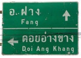
Doi Angkhang, Fang District is the side of the Royal Agricultural Project accessible via highway 107, with a left turn at kilometer 137 and then along a steep winding road for another 26 kilometers to the top of the hill. It is here that substitution crops for opium are being grown including fruits, flowers, vegetables and herbs, along with other cash crops grown for the purpose of agricultural development among the hilltribes in the area, including the Luha, Pha-Lhong, Yunnanese and Thai Yai. At Doi Ang Khang visitors can see plants being cultivate in this cooler climate including apricots, peaches, plums, carrots, salad greens and beautiful flowers such as carnations, roses, asters and chrysanthemums.

There is also a packing plant within the Royal Project .Cooperative's compound where visitors can buy fresh produce. Another attractive place to visit there is the Bonsai garden with its large collection of miniaturised plants from both tropical and temperate climates. Visitors may also hire from here a pick-up truck to go to Tha Kha market. In Doi Angkhang you can also find accommodation including private lodgings.

Doi Angkhang is Bankum 1 M 5 , T. mae-ngon , A. fang , chiangmai 50320

The locals in Doi Ang Khang grow wide range of fresh produce including vegetables, fruits and herbs. Not only this, various species of flowers are also cultivated here. To contribute towards the agricultural growth of the region, several cash crops are also grown here. It will be fascinating to see the activity of cultivation on the mountain


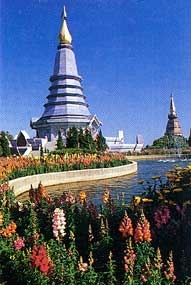
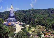
Doi Ang Khang, also houses a Bonsai garden. The garden flaunts a large assortment of bonsai plants from various regions. The mountain also features Royal Ang Khang Research Station. It is an agricultural project station that was founded in 1969. This demonstration site was set up to cultivate and conduct a research on flowering plants, temperate fruit trees and vegetables.

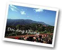
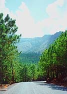
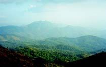
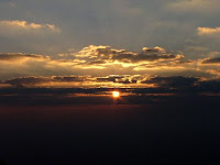
Doi Ang Khang, Chiang Mai is also growing into steep popularity for mountain trekking in Chiang Mai. The mountain attracts adventure enthusiasts who love thrill and excitement. This place plays an important role in growth of Chiang Mai tourism.Doi Ang Khang features an exceptional natural beauty. It offers magnificent and beautiful views of the city. If you are planning to visit Doi Ang Khang , do carry some warm clothes, as it might get cold during the night. You can also opt to stay in several guesthouses and hotels on Doi Ang Khang . Do enjoy facilities like bird watching, mountain biking and trekking.Doi Ang Khang is a three hour drive from Chaing Mai. It is located in a rather remote part of northern Thailand, so renting your own car and driving yourself is the best way to get to the mountain park. Chiang Mai is also home to the nearest airport and offer guided tours to the mountain. Chiang Mai is easy to reach from anywhere within Thailand by bus, train, and air.
Located about 100kms north of Chiang Mai, the area of Doi Angkhang offers a remote experience that has yet to be overrun with tour buses and camera-toting visitors. The highest peak is 1300m and is accessible by car. With cool year round temperatures, it’s not surprising that Doi Angkhang is referred to as the “Little Switzerland” of Thailand. It’s possible to drive right up to the border post and gaze across a small saddle at the ramshackle Burmese army camp and sweeping landscape beyond.

The road descends into a small village located in the bowl-shaped valley from which the area takes its name and here you’ll find the plush Amari Angkhang resort – promoted as an eco-friendly lodge. Indeed they have made particular effort to incorporate local resources, including people, into their day-to-day running and have minimised their effect on the environment. The resort abuts a hillside forest reserve full of nature trails, and there are also bird-watching activities, as well as horseback riding and even mountain biking trails for the brave.
 In the nearby Doi Angkhang village, you will encounter a market where hill tribe folk sell their woven and handicraft products, and a few modest guesthouses can be found. The road continues along the valley for a further three kilometres before terminating in a forestry centre. Here you can witness first hand the successes of the King’s Project to wean the local people off opium production and into more savoury agriculture

Evidence of wide scale poppy harvesting in the past is still seen in the swathes of cleared mountainside. But today, this national Royal project, which was piloted in this area 20 years ago, has left the area covered in greenhouses. You may visit these, and purchase organic vegetables and fruit as well as potted plants, and visit the excellent flower gardens here which include a large English rose garden and rows of Rhododendrons.

Doi Angkhang
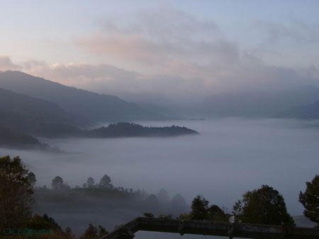
The atmosphere is quiet and peaceful with a wall of mountains in all directions. You also have the opportunity to visit some of the villages of the several different hill tribes who live here, including the Lahu, Lisu and Hmong, as well as the rare Palong. There is a settlement, Baan Nong Mai Bua, populated by the Chinese KMT who escaped to the region fifty years ago after Mao defeated Chiang Kai Shek. Even today it remains very Yunnanese in character.

10 ก.ย. 2553

Khao San Road

 
 Khao San Road
Where the worlds young travelers meet. Khao San Road is a favourite crossroads for the young travelers on a budget. It has evolved over the last two decades from just one small hostel providing low-budget accommodation become one of the worlds most well-known destinations. It has been featured in many movies and television documentaries.


During the day, Khao San Road is the scene for back-packers looking for a cheap room while others are arranging transport to their next destination in Thailand or overseas. Some will be just chatting with friends over a cup of coffee or a bowl of noodles.
At night, it turns into a lively thoroughfare lined with street stalls selling cheap clothes, handicrafts, souvenirs and thousands of other items. The lights are on at the many bars where the travelers tell tales of the days adventures and discoveries and the plans for tomorrow. Khao San Road is not just for foreign travelers, many young Thai people like to hang out there, including members of the TV and film production industries.


The location is very convenient for visiting the many tourist attractions on Rattanakosin Island. It is just a 10-minute walk to Sanam Luang and The Grand Palace.
During April when Thais celebrate the Songkran Festival, Khao San Road becomes a fun-filled battleground as everyone, Thais and foreigners indulge in splashing each other with water.The area is also well-known for the wide variety of inexpensive food. This ranges from spicy Thai Tom Yum Gung soup to the ever-popular banana pancake.


You can check all the accommodations in Bangkok including prices, transportations, activities, etc. here, Bangkok Hotels.P.S. For gentlemen who want to understand more about Thai culture, discover the charm of Thai life, or may happen to think about having a Thai wife, this is the information you will have to know, click here.

2 ก.ย. 2553

Doi Suthep


Doi Suthep
Doi Suthep
Covering an area of 262 sq. km.This luxuriant Park is home to more than 300 bird species and nearly 2,000 species of ferns and flowering plants. Some hiking trails in the park pass Hmong villages while others lead to a few small waterfalls where local people come to picnicking on weekends. Accommodations are available near the park headquarters. To get there, take Highway No. 1004, its only 16 kilometers drive northwest of Chiang Mai town. The Park has interesting attractions, which include:The Roof of Thailan


Wat Phra That Doi Suthep

Locals would say, You havent really gone to Chiang Mai unless youve been to Wat Phratat Doi Suthep. Truly, the place is the most important and famous Chiang Mai landmark. Built in 1383, this mountaintop temple has a chedi (pagoda) that houses holy Buddha relics. The gold-plated chedi lies in the middle of a square marble-tiled courtyard. The four corners of the chedi are adorned with parasols which represent royal regalia. The temples courtyard is lined by a cloister, which contains images and murals depicting Buddhas life. There are also two viharns situated in the middle of the east and west sides of the cloister.
This temple is 15 kilometers from town and is 3,520 feet above sea level. It is the perfect place to get a birds eye view of the city. The temple can be reached via a steep Naga staircase comprised of 290 steps or railcars. The temple is open daily from 6 a.m. to 7 p.m.
Wat Phra That Doi Suthep

Doi Inthanon National Park

Doi Inthanon National Park
Doi Inthanon
Doi Inthanon was declared a National Park in 1972 and covers an area of more than 1005 square kilometres and is probably Thailand’s best known National Park being the home of the country’s highest mountain, Doi Inthanon, which stands at 2565m (above sea level) and is thus dubbed ‘the Roof of Thailand’.the park is comprised of the largest tract of upper mountain forest Which ranges across Nepal, Bhutan, Myanmar, and ends in Northern Thailand. The mountain ranges gave birth to the main tributaries of the Ping river and formed the beautiful waterfalls, namely Siriphum, Wachirathan, Mae Pan, Mae Klang and Mae Ya. The moist and dense evergreen forest is abundant with lichens and wild orchids. The park is also a paradise for bird lovers. Visiting Doi Inthanon is possible throughout the year however,
the best period for viewing the waterfalls is May through November while the best period for viewing wild flowers is December through
The National Park is located only some 110 kms south west of Chiangmai making it ideal for a one-day trip from the city. Many tour companies offer this as a one-day tour but you should consider hiring a car, complete with driver if Thailand’s traffic is intimidating. This gives you increased freedom of movement and is the option I recently took along with three friends. Leaving Chiangmai we followed Highway 108 until just north of the town of Chom Thong where we turned off and made the ascent along the well-maintained road, directly to the summit.

At first glance the summit appears to be a disappointment with a sealed off military radar establishment at the end of the road. The best time to visit is in the cool season although at this altitude it can get a little chilly at all times of the year. In fact, not only is this Thailands highest point but also, according to records, its coldest. Today was no exception and as we set out to explore the two Thai members of our group, unaccustomed to the cold, were reaching for jackets immediately. We followed a path into the forest and reached a sign declaring this to be ‘the highest point in Thailand’

If you have more time Doi Inthanon is home to the Doi Inthanon Royal Project which can be found at Baan Khun Glang (บ้านขุนกลาง), about 11 kms off the main road near the kilometre 31 marker. The Project promotes a variety of agricultural practises through the mountain’s resident Karen and Meo hilltribe comunities and can be visited. Due to the climate on the mountain, cold weather flowers such as chrysanthemums and carnations make rare appearances for Thailand as do strawberries and apples.

There are also a number of hilltribe villages that can be seen but due to the number of visitors they receive the majority could hardly be described as unspoilt. We headed back towards Chiangmai but for a sample of hilltribe life we made a stop at a roadside Hmong market where the two ladies in our group stocked up on various produce that was well priced and not readily available in Chiangmai. Some of the elder Hmong were dressed in traditional costume and after making the effort to be polite, smiling a lot, and making a few purchases were only too happy to be photographed.
This was an enjoyable end to a thoroughly relaxing day and how I wished I could take the clear fresh air back into Chiangmai with us but held out little hope of such good fortune.


Doi Luang Chiang Dao

Doi Luang Chiang Dao
Doi Luang Chiang Dao is a limestone mountain in the Chiang Dao Wildlife Reserve area, Amphoe Chiang Dao. This cone-shaped mountain is 2,195 metres from sea level, which makes it the third highest mountain in Thailand after Doi Inthanon and Doi Pha Hom Pok. Narrow plains on top of the mountain overlook spectacular views that include a sea of fog on the Amphoe Chiang Dao side, Doi Sam Phi Nong, the Chiang Dao mountain range, and the far end of Doi Inthanon. The peak is cool and windy. It is full of rare highland flowers, birds, and butterflies. Visiting Doi Chiang Dao needs an approval letter from the Director of Wildlife Reserve Division, Royal Forest Department. Travel must be arranged at least 2 weeks in advance. Contact tel. 0 2561 2947 for more information.

How to Get There


From the town of Chaing Mai, take highway 107 to Amphoe Chaing Dao. Here you will go to Kilometer 76. Turn left here and go straight for five kilometers to the Chaing Dao Cave. Here you will see the mini bus that will take you Den Ya Khad Ranger Unit. The total distance from Chaing Mai is 77 kilometers

Doi Luang Chiang Dao

Sponsored Link